by Phil Rowe
After my recent abortive attempt to paddle the east end of Lake Powell due to high
winds, strong enough to blow my tent down in a driving rain, I was determined to paddle
elsewhere. So early on the morning of June 10th last, I headed east along I-40 from
Albuquerque toward Santa Rosa Lake. The lake is formed by a dam on the Pecos River, that
historic stream of legend in the wild west days of cattle drives and feuding ranchers.
It's on the high plains at about 4300 feet above sea level.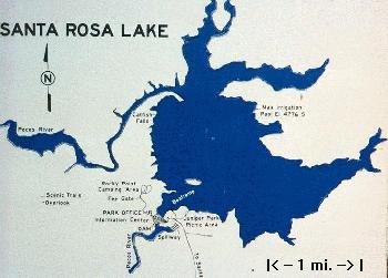
There was no traffic at all as I crossed town from my house at 4:15 A.M. to get on the Interstate. Soon I was cruising eastward toward Moriarty, where I stopped for breakfast at a truck stop, and thence on to Clines Corners and Santa Rosa, about 120 miles from Albuquerque. The sun was coming up as I reached the turn-off to the lake. It's actually seven miles north of the town of Santa Rosa.
At the lake, near the dam, is a delightful state park. It features two camping areas, one with minimal RV hookups (water and electric) and another for bare bones campers. A visitors' center with rest rooms overlooks the western end of the lake, and not far away is the boat ramp, a paved access for boat trailers and even kayakers like me. That paved ramp is very steep and I would be reluctant to attempt driving a heavy boat and trailer rig down toward the water. Lots of parking is available for tow vehicles and trailers, as well as another toilet facility and drinking water.
Winds are from the west and even at this early hour, about 7:15 A.M., show signs of freshening as the morning wears on. I don my life jacket, paddling gloves and a protective sun hat before launching my craft. This is my first paddling of the season and I am anxious to be out there on the water.
Santa Rosa Lake is not very large, but it is quite popular with eastern New Mexicans and some west Texans. It's known too for a very deep hole frequented by scuba divers. Fishing is reportedly good and the lake is stocked frequently. Because the winds are showing signs of getting stronger, I head north along the western shore and take advantage of the lee of cliffs. It's relatively calm once I clear the cove off to my left, where the winds are stiffly blowing down a canyon leading toward the dam. Whitecaps and foot-high waves are already making open expanses rough, but in the lee of the shore it's quite calm and much easier paddling.
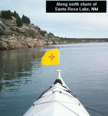
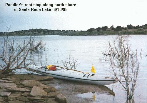
About two miles up the western shore I find a convenient place to stop, to take pictures and stretch my legs. Much of the shore in this area is comprised of layers of flat rock, sandstone or something similar. The layered cliffs seem to be made of stacks of six-inch slabs piled one atop the other. Many large pieces look like flagstones waiting to be quarried for home landscaping and patios. Those at the water's edge are covered with algae and quite slick and slippery to walk upon. And though the waters are fairly clear, there is suspended dirt to limit downward viewing to perhaps just six feet. I was surprised to find the waters fairly warm, even this early in the season, for much of the inflow comes from snow melt in the mountains east of Santa Fe.
I continued north to the end of the lake. There were few signs of wild life, just some fish jumping and one large bird that looked like an overgrown cormorant. It was interesting to observe the grasses and small shrubs that clung to the cliff walls, Every possible niche and nook that could support even the tiniest plant was occupied. I wondered how they could find nourishment for growth on those rocks, yet there they were. Some were even flowering. Hardy plants they were indeed.
Paddling east and southward was out of the question today, for with those west northwest breezes picking up I knew it would be rougher on the opposite side, as well as lots of work paddling into the winds on the way back to the boat ramp launch area. No, I decided. I'll stick to the lee of these cliffs. I was here to enjoy the outing and not test myself against the elements.
There are a couple places along the shore where park officials have erected wind indicators and small wind-powered electrical generators which operate flashing strobe lights. When winds get above 20 knots or so those lights flash to warn boaters that it might be getting too rough for safety. I observed two such units flashing steadily and elected to head back to my launch area.
As I rounded the tip of land, my last lee shore protected area, and headed across the mouth of a cove exposed to the full force of the wind, I was met with really strong headwinds. Whitecaps and rough waters greeted me for this last third of a mile, so I chose to head into the wind and then make my way cross-wind closer to the dam. It was not unpleasantly rough, but it sure was a bit of work against the wind in my face. It's like paddling up hill and I was glad it wasn't a couple of miles to go.
Back at the boat ramp I disembarked, stowed my gear and placed the stern of my craft atop a two-wheel dolly to make it easier toting my boat up to the car. Yes, it was a prudent decision to call it quits, for the wind was now even stronger. I was happy though and called this paddling excursion a success. I'll be back one day to do the rest of this interesting lake in New Mexico's eastern plains.
Learn a little about Phil Rowe
Return to The Canoe Camper's Home Page.